pos-eye-badge UpGrid
Territory Management Platform

Manage your territories. From a browser. Without GIS expertise.

UpGrid gives operations teams a spatial platform to define service zones, delivery territories, and coverage areas — and keep them updated as the business changes.

Browser-based — no desktop GIS software
API-ready — connects to your existing stack
Built on Placematic spatial infrastructure
upgrid.placematic.com
UpGrid areas designing
Who uses UpGrid

From messy spreadsheets to managed territories — in four steps.

01
Define territories
Draw service zones, sales regions, and delivery areas directly on a map. Import from postal codes, administrative boundaries, or custom data.
02
Assign locations
Import customer points, depots, and service locations. UpGrid assigns every location to the right territory automatically — no manual lookup.
03
Query from anywhere
Ask "which territory covers this address?" via REST API. Integrate territory logic into dispatch systems, CRMs, and custom tools.
04
Monitor coverage
See gaps, overlaps, and utilization across your entire territory structure. Adjust boundaries as your team and business change.
Organize your data

One place for all your spatial data.

Store and manage your territories, service areas, customer locations, and competitor data in a single platform.

Fleet & ELD

Import, organize, and version-control spatial data. No file management or coordinate formatting required.

Locations

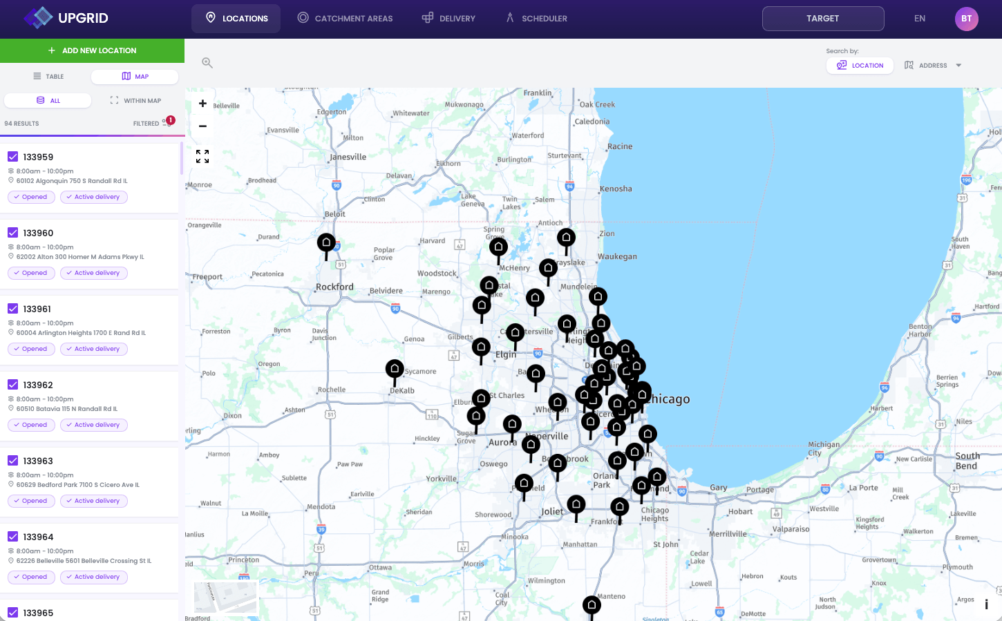
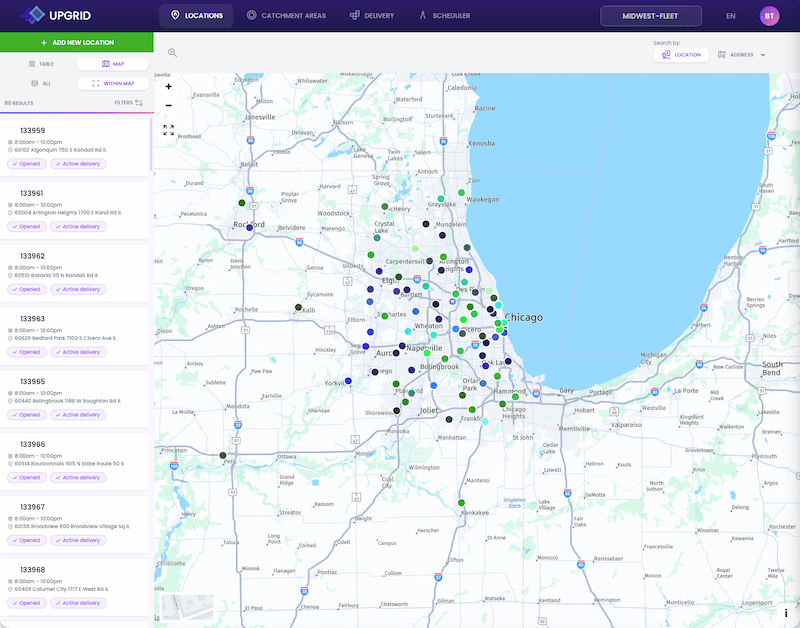
Store your points in structured layers — customers, depots, service locations, competitors. Query them spatially.

Areas

Define polygons for territories, zones, and boundaries. Use them as filters, assignment logic, or coverage indicators.
upgrid.placematic.com
UpGrid areas designing
upgrid.placematic.com
Create data

Draw, import, or generate — your territories, your way.

Design areas that make sense

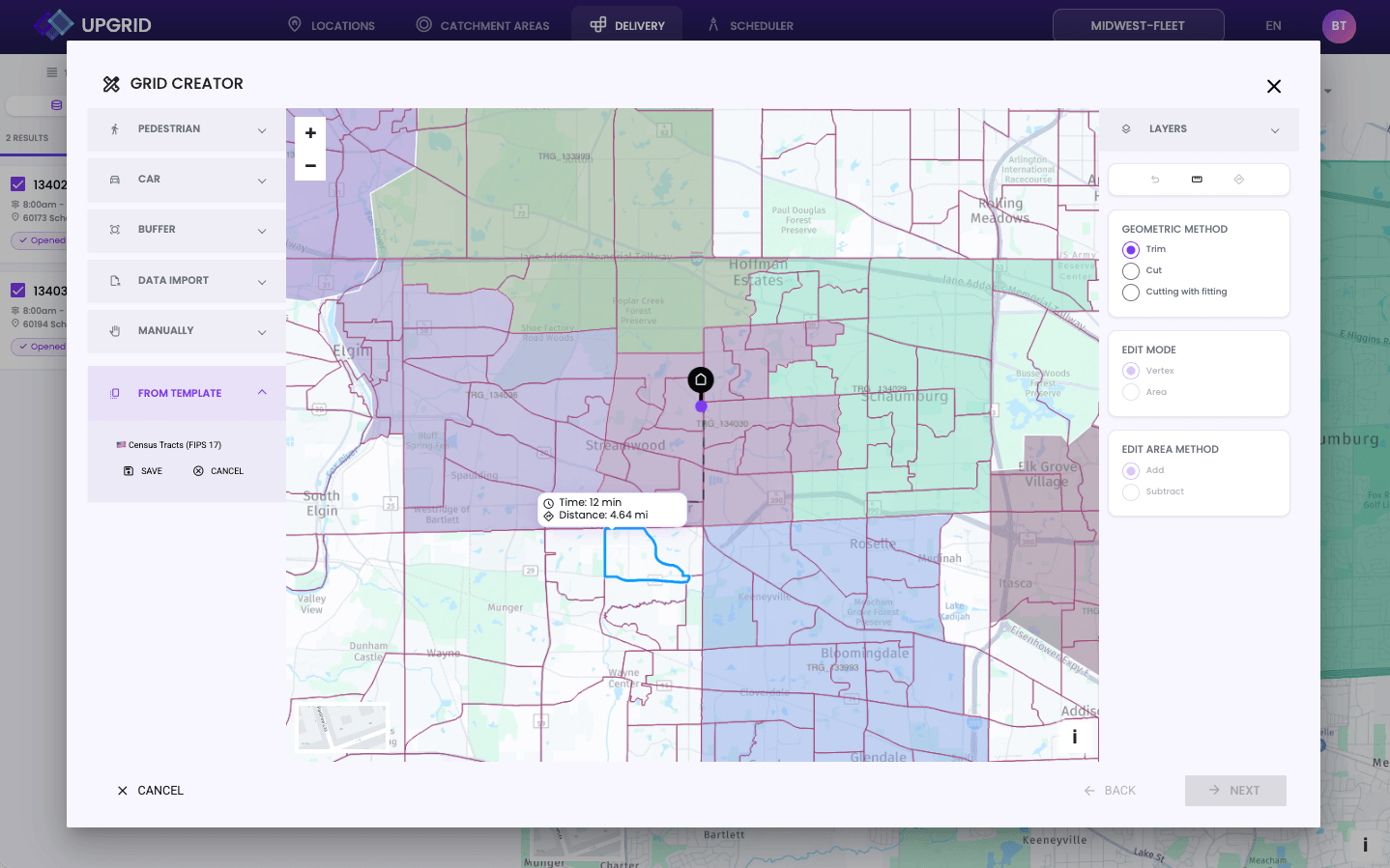
Draw territories manually on the map, generate them from postal codes or administrative boundaries, or build them from data inputs like customer density or sales volume.

Edit quickly and accurately

Modify boundaries by trimming them against any shape or existing layer. UpGrid maintains topological correctness automatically — no gaps, no overlaps.
Use the data

UpGrid data works everywhere you need it.

Integration

UpGrid exposes a spatial API that lets you use territory data in external applications — dispatch systems, CRMs, fleet management platforms, and custom tools.

Share

Share territories with clients or partners as data exports, map embeds, or API feeds. UpGrid acts as the authoritative source of your spatial data.
API Reference
Webhooks
Exports
Embeds
v2.4 · stable
Endpoints
GET /territories
GET /territories/:id
POST /territories
GET /locations/lookup
POST /assignments
GET /coverage/:id
Connections
Salesforce CRM
Fleet Tool
HERE Routing
Webhook · Slack
// Lookup which territory a customer falls into
GET /v2/locations/lookup?lat=41.8781&lng=-87.6298

{
  "location": {
    "lat": 41.8781,
    "lng": -87.6298,
    "address": "233 S Wacker Dr, Chicago, IL"
  },
  "territory": {
    "id": "trr_chicago_metro",
    "name": "Chicago Metro",
    "assignee": "driver_jp_24",
    "layer": "midwest-fleet/zones",
    "coverage": 0.98
  },
  "updated_at": "2026-04-29T10:14:22Z"
}

// Export as GeoJSON, Shapefile, KML, or live feed
GeoJSON Shapefile KML CSV Live API
Pricing

Estimate Your UpGrid Costs.

Pricing based on the number of POI locations in your account.

Starter
$350
/mo
Best for: Small teams and pilots
Included: Up to 25 POIs
Core territory management
Browser-based editor
API access
Email support
Growth
$500
/mo
Best for: Growing operations
Included: Up to 50 POIs
Everything in Starter
Territory versioning
Team collaboration
Priority support
Most popular
Scale
$2,000
/mo
Best for: Multi-location brands
Included: Up to 100 POIs
Everything in Growth
Advanced spatial analytics
Custom integrations
Dedicated onboarding
Enterprise
from
$2,000
/mo
Best for: Large networks
Included: 500+ POIs
Custom volume & SLA
Dedicated account manager
Custom data pipelines
Private cloud
Ecosystem

UpGrid connects to everything you already use.

Works with
Used in
Placematic Spatial API
Territory queries, spatial search, and geocoding via REST.
Fleet & ELD
Define service zones and assign driver coverage areas.
HERE Routing API
Truck-aware routing integrated with UpGrid service zones.
Define service zones and assign driver coverage areas.
Manage delivery zones and eliminate coverage gaps.
Placematic Geocoding API
Address validation and coordinate resolution for territory assignments.
Retail & Franchise
Protect franchise territories and define trade areas.
UpInsight
Feed territory data into geomarketing analytics and network performance reports.
Field Services
Assign technicians to service areas across distributed operations.

Frequently asked questions.

UpGrid is Placematic’s browser-based territory management platform. It lets operations teams define, visualize, and manage geographic territories — service zones, delivery areas, sales regions, and franchise boundaries — without GIS software or technical expertise. You draw territories on a map, import location data, and use it through a web interface or API.

No. UpGrid is built for operations managers, logistics teams, and network planners — not GIS specialists. Everything runs in a browser. No desktop software, no coordinate systems, no file format conversion required.

Google Maps and similar tools are built for navigation and consumer use — not for managing business territories. UpGrid is built specifically for defining, assigning, and maintaining geographic coverage areas as operational data. It includes API access, team collaboration, spatial data storage, and integration with routing and geocoding services — none of which generic mapping tools provide.

Yes. UpGrid exposes a spatial API that lets you query territory data from external applications — dispatch systems, CRMs, fleet management platforms, and custom tools. Territory assignments, coverage queries, and zone lookups are all available via REST API with JSON responses.

Pricing is based on the number of POI locations in your account. Plans start at $350/month for small teams (up to 25 POIs) and scale to $2,000/month for multi-location brands (up to 100 POIs). Enterprise pricing is available for networks with 500+ POIs. All plans include API access and browser-based territory management.

Yes. We offer a structured pilot scoped to your actual use case — not a generic sandbox. Submit a trial request and we’ll set up access within 1 business day. No credit card required to start.

You can import location data in standard formats — CSV, GeoJSON, and common spatial file types. This includes customer locations, depot addresses, service points, competitor locations, and any point data relevant to your territory planning. UpGrid stores and organizes them in structured layers.

Yes. UpGrid maintains topological correctness — it detects and manages gaps, overlaps, and shared boundaries between territories. When you edit a boundary, adjacent territories update automatically to maintain a clean, consistent coverage map.

UpGrid is built and operated by Placematic USA LLC — a Location Intelligence SaaS company based in Rolling Meadows, IL. Placematic is a HERE Technologies Gold Partner since 2016. UpGrid runs on Placematic’s own spatial infrastructure — not a third-party white-label product.

Ready to take control of your territories?

Start a pilot or book a 20-minute demo — we'll show you UpGrid with your actual use case.